
Monthly revenue
Available on Pro
Monthly downloads
Available on Pro
Rating
—
Price
$4.99
Subscribers only
Subscribe to see revenue estimates, ads, complaints and keywords.
Launch offer: 50% off until October 31, 2026
Monthly revenue
Monthly downloads
Rating
Price
Subscribe to see revenue estimates, ads, complaints and keywords.
Launch offer: 50% off until October 31, 2026
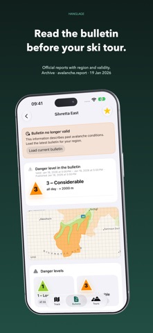
Ski touring, trail running and hiking with iPhone and Apple Watch. Find routes in the Alps and check them on the map and elevation profile. Download maps before setting off and record on iPhone or Apple Watch. For ski tours, you can also view terrain slope, protected-area information and official avalanche bulletins. FIND ROUTES IN THE ALPS Search by tour, summit, region or place, or find nearby routes. The Alpine catalogue includes ski tours and summer routes from Austria Tourism, swisstopo, BayernCloud, Camptocamp and selected OpenStreetMap routes. Details show the route, elevation profile and original sources. Difficulty, season months, refreshment stops and photos appear when the source supplies them and usage rights allow. PATHS, CONTOURS AND TERRAIN SLOPE Topographic maps show paths, contours and terrain in 2D or 3D on iPhone. Add layers for slope angle, routes and protected areas. Track colours show the gradient along your route. Import your own GPX files, select a tour to follow or reverse its direction. DOWNLOAD MAPS BEFORE SETTING OFF Download an area or a corridor along your route together with its tours before heading out. Apple Watch can download its own map areas too. Check that downloads are complete before you start. Downloads and updates require internet access. RECORD ON IPHONE OR WATCH Choose the device that records your workout. Apple Watch can also record without iPhone. During recording, see distance, elevation gain, duration and available heart rate data. Customize your dashboard with 2, 4, 6 or 8 fields, including altitude, pace, average ascent rate (VAM) and available running power. With your permission, workouts are saved to Apple Health. READ OFFICIAL AVALANCHE BULLETINS Read reports from supported avalanche warning services in Germany, Austria, Switzerland and Italy. Downloaded bulletins remain readable offline, with their dates, validity and regions visible. An inclinometer, altimeter and widgets complement the app. BEFORE YOU HEAD OUT The trail running filter includes hikes; it does not confirm suitability for running or current access. Elevation profiles may include labelled terrain-model estimates. Ski tours are saved to Apple Health as outdoor runs; Hanglage retains your selected sport. Running power comes from available HealthKit samples and is not a validated ski-touring power measurement. Check original sources and conditions on the ground. Hanglage does not replace training, route planning or safety equipment. Try Hanglage Pro for seven days after first launch. After the trial, tracking, slope overlays, route layers and wildlife protection zones require a subscription. Avalanche bulletins and measuring tools remain free. Terms of use: https://www.apple.com/legal/internet-services/itunes/dev/stdeula/



Not on the US charts right now.