
Weekly revenue
Weekly downloads
Rating
Price
Weekly revenue
Weekly downloads
Rating
Price
Subscribe to see revenue estimates, ads, complaints and keywords.
Launch offer: 50% off until October 31, 2026
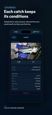
NEW — DEPTH MAPS AND DETAILED FISH SPECIES Download depth maps for 12 European seas and use them offline. Open a detailed profile for every fish species with description, habitat, behaviour, recommended baits and lures. Tisch Fishing Europe is a fishing forecast for 6 European seas — the Adriatic, Mediterranean, Atlantic, North Sea, Norwegian Sea and Baltic. Every morning the app tells you the BEST HOURS for fishing using solunar calculations, hourly weather forecasts, tide and pressure data. All combined into one clear score from 0 to 100. WHAT YOU CAN DO: MAP — see the current state of the sea for your location or any European sea: temperature, wind, pressure, humidity, wave height and sea temperature. FORECAST — a seven-day fishing forecast with scores, hourly chart and broken-down factors (solunar, pressure, wind, sun, tide, clouds). Detailed tide tables with exact times. ADVISOR — smart recommendations on which fish to target today, with what technique and which bait. Covers 84 species — from sea bass and john dory to octopus, cuttlefish, bluefish and tuna. CATCH LOG — record every catch with photo, weight and location. The app automatically saves temperature, wind, pressure, moon phase, tide and fishing-forecast score at that moment. SETTINGS — automatic zone from GPS or manual selection, morning alarm with daily scores, dark mode, favourite fish. WIDGET — fishing forecast for tomorrow and the day after directly on your home screen. Three widget sizes. ACCURATE DATA FOR EVERY LOCATION Tide data comes from trusted sources: WorldTides (global coverage), Norwegian Hydrographic Service (Kartverket), UK Admiralty, Spanish IHM, UNESCO IOC Sea Level Monitoring, German BSH/Pegelonline and Danish DMI. Weather forecasts from Open-Meteo (high-resolution ECMWF and ICON models). Solunar calculations follow the classic John Alden Knight method. COVERAGE ZONES: - Adriatic Sea (Trieste to Otranto) - Mediterranean Sea (Gibraltar to Suez) - Atlantic (Portugal, Spain, France, UK, Ireland) - North Sea (Netherlands, Belgium, Germany, Denmark) - Norwegian Sea - Baltic Sea FOR BOAT, SHORE AND SPORT FISHING Whether you fish from a boat, kayak, pier, beach or shoreline — the scored fishing forecast helps you pick the right hour and the right spot. Solunar peaks show up to four daily windows when fish are most active. The app also works offline for locations already loaded. No ads. No subscriptions. Pay once, use forever. AVAILABLE IN 17 LANGUAGES — Croatian, English, Italian, German, French, Spanish, Portuguese, Dutch, Norwegian, Swedish, Danish, Greek, Turkish, Slovenian, Serbian, Montenegrin and Macedonian. The app does not sell your data. Location is used only locally to find the nearest fishing zone and tide station.




Not on the US charts right now.