Monthly revenue
Monthly downloads
Rating
Price
Monthly revenue
Monthly downloads
Rating
Price
Subscribe to see revenue estimates, ads, complaints and keywords.
Launch offer: 50% off until October 31, 2026
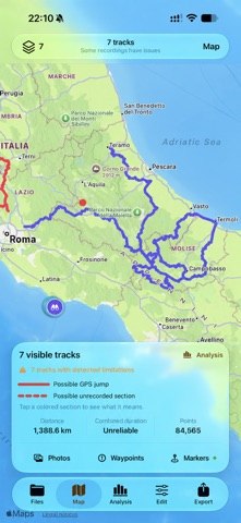
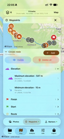
WHEN THE JOURNEY ENDS, GPXPLORER PRO BEGINS. Every track holds more than a route: stops, photographs, places to remember and details to rediscover. GPXplorer Pro helps you explore it all, turning your GPX and KML archive into a library with maps, analysis, diagnostics and editing tools. For trekking, hiking, cycling, motorcycling and any activity recorded with GPS tracks. YOUR FOLDER IS ALREADY YOUR LIBRARY Connect a folder accessible through the Files app, on your iPhone, iCloud Drive or a compatible provider. Find your routes with thumbnails and automatic classification, without moving your documents into a closed library. Your files stay where you organized them, accessible from other apps and devices. REDISCOVER YOUR PHOTOS, EVEN YEARS LATER Rediscover photographs from your trip and those taken along the same route on other occasions. GPXplorer Pro combines dates, times and locations to connect images with tracks, letting you revisit the same places through different seasons and memories. Explore photos on the map with 2D or 3D terrain, identify inconsistencies between times and locations, and correct photo GPS coordinates or dates. Geotag photographs without coordinates, or use a reference photo to realign the track’s timeline. A MAP THAT HELPS YOU UNDERSTAND View routes on Apple Maps, satellite imagery and OpenStreetMap. Automatic markers highlight the start, finish, stops, elevation extremes, grade and speed, kilometer references, recorded times and progress along the route. Map data adds context: parks, summits, mountain passes, mountain huts, crossings and surface types. Choose which markers to display and inspect the details at points that interest you. Open multiple tracks to compare them and analyze their combined totals. IMPORTANT POINTS STAY IN YOUR GPX Add waypoints using the map crosshair, create them from automatic and cartographic markers, or enter them manually. Organize them by category, inspect their coordinates and elevation, and choose which ones to display. A stop, a summit or a viewpoint can become a reference point saved alongside your route in the exported GPX file. DIAGNOSTICS THAT EXPLAIN, BEYOND THE NUMBERS GPXplorer Pro checks GPS continuity, the timeline and measurement reliability. It detects position jumps, missing sections, invalid coordinates, inconsistent timestamps and unusual intervals. Each issue is explained and, where possible, highlighted on the map. Geometry, elevation, speed and timing are assessed separately, adapting the statistics to the actual quality of the data. FROM THE FILE YOU HAVE TO THE ROUTE YOU NEED Split a recording into multiple tracks, extract a section between two points, or merge routes in the order you choose. Edit the GPX title, description, author, links and rights. Correct the timeline and prepare your tracks for archiving, reuse or sharing. Changes are prepared before saving. You can keep a copy or choose to replace the original file after the export has been verified. VERIFIED EXPORT The result is compared with the original to preserve details, metadata and compatible extensions, including data the app does not display directly. Export your route as GPX or save the map as a PNG image. YOUR ROUTES, UNDER YOUR CONTROL No account, no advertising and no tracking. Analysis, diagnostics, transformations and export verification take place within the app. Photos are accessed only with your permission; maps and geographic information use your selected services. GPXplorer Pro has no subscriptions or in-app purchases.
Not on the US charts right now.