
Haftalık gelir
Haftalık indirme
Puan
Fiyat
Haftalık gelir
Haftalık indirme
Puan
Fiyat
Gelir tahminlerini, reklamları, şikâyetleri ve anahtar kelimeleri görmek için abone ol.
Lansman fırsatı: 31 Ekim 2026 tarihine kadar %50 indirim
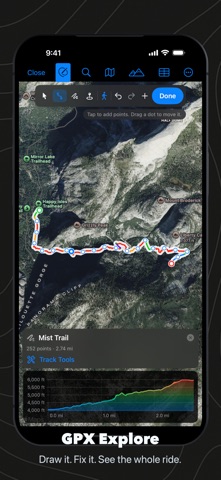
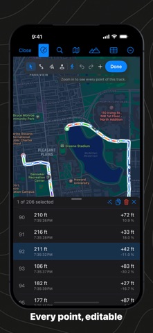
Open a GPX file and see the whole ride. Or draw a new one, fix a recording, and save plain GPX that every device reads. GPX Explore is a GPX viewer and a GPX editor on the Mac, iPhone and iPad. DRAW A ROUTE (PRO) Click on the map where it starts, then where it goes. Draw straight lines, or let Apple Maps follow the paths and roads for walking, cycling or driving. Drag any point you clicked and the route finds its way again. Trace freehand with the mouse, a finger or Apple Pencil. Close the loop back to the start, or make it an out-and-back, in one click. Elevation for every new point comes from a 30 m terrain model, so the climb is on the chart before you leave. FIX A RECORDING (PRO) Cut off the drive to the trailhead. Delete the GPS spike across the lake. Drag a point back onto the path. Select a stretch on the map (or drag across the chart on the Mac) and delete it, crop to it or split the track there. Join two days into one, reverse a route, simplify ten thousand points to the few hundred a bike computer accepts, add points to long straight legs, replace noisy altitude, shift times from a watch with the wrong clock, or give a planned route times at your pace. Every change can be undone. EVERY POINT IN A TABLE (PRO) Open the Points table to see each point's position, height, time and heart rate, with the gap, speed and grade from the one before. Sort a column to find the bad ones, then type a new value or delete them. The map, chart and table always show the same point. SEE THE CLIMB IN COLOUR The track is painted by grade: green on the flat and the gentle climbs, orange and red on the steep pitches, blue to purple on the way down. A second mode colours by elevation, on standard, satellite and hybrid maps. EVERY NUMBER YOUR WATCH RECORDED Heart rate, cadence, power, speed and temperature from Garmin, Strava, Wahoo, Coros, Suunto and Apple Watch files, charted under the map. Scrub the chart and the marker follows on the map. The route card sums it up: distance, moving time, pace or speed, elevation gain and loss, sensor averages and splits. YOUR FILE, KEPT WHOLE Saved as standard GPX 1.1. Everything the file had comes back out: metadata, links, waypoints with symbols, routes, segments, fix quality, heart rate and power, and each app's own extensions, down to Garmin's track colours. A file you open and save without edits is written back byte for byte. MADE FOR THE MAC Double-click a .gpx to open it, ⌘N to draw a new one. Right-click the map for waypoints and splits, ⌥-drag to trace, a Track menu with every tool, and the keyboard shortcuts you expect. Quick Look in Finder shows the track in colour. A welcome window gets you started, with a sample run to try. ON IPHONE AND IPAD The same editor, made for a finger: tap to add points, drag to move them, long-press for more. Open a GPX from Files and edit it where it is; from Mail or Messages, GPX Explore keeps a copy. In Files, every GPX file shows its own track on a map. PRIVATE BY DESIGN No account, no sync, no ads, no tracking. Your files stay on your device. Viewing a file sends nothing beyond the Apple Maps tiles for the map and for file thumbnails. When you draw or move points, GPX Explore sends just their coordinates to our own elevation server to look up the height, and, if you choose to follow roads, asks Apple Maps for directions. The elevation lookup can be turned off. Viewing any GPX file is free. Drawing and editing are GPX Explore Pro, one purchase for your Mac, iPhone and iPad. In English, German, French, Spanish and Japanese.



Şu anda ABD listelerinde yok.